
Preliminary Concepts of Astronomy:-
Vedic astrology has its base in astronomy. A preliminary knowledge of astronomy is required for an astrologer. A fair concept of the rotation of earth, the occurring of eclipses, concept of lunar and solar months, formation of seasons, the equinoxes, the concept of zodiac, ecliptic, celestial Equator, fair concepts of the placement of the planets and stars in the sky, celestial longitudes and latitudes of the planets, the first point of Aries or the Vernal Equinox, the first point of Libra or the Autumnal Equinox etc, is required to be acquainted with fully, by a student of astrology before venturing to learn and then practice astrology.
Earth: – The Earth is revolving on its own axis. In addition to its spinning, it is also revolving around the Sun. Though it is known that the Earth is moving like other planets round the Sun, yet, for the purposes of the Vedic astrology, the ancient Geocentric system is followed when the Earth is taken as the centre of the universe and predict the astrological results accordingly. Earlier the Earth was considered as the centre of the solar system, with the rest of the heavenly bodies in the universe in constant motion around it, in their individual manners. Such a situation in astronomical terminology is called as Geocentric. The other position is Heliocentric, when it considers Sun as the centre as solar system. The Indian astronomy is thus Geocentric and not the Heliocentric. Our Vedic astrology is known as ‘Pratyaksha Shastra, which refers to the visible or the apparent movement of the planets. It has a relationship with the ‘Geocentric Observations astronomically.
While living on the Earth’s surface the creatures living on the Earth also keep on moving in the space with the same speed as that of Earth. Sun, which is actually stationary, appears to be moving in opposite direction to that of the Earth. As the Earth moves from west to east, the Sun and other stars and planets in the space appear to move in the opposite direction, which is from east to west. Earth is the third planet from the Sun and the only astronomical object known to harbor and support life. About 29.2% of Earth’s surface is land consisting of continents and islands. The remaining 70.8% is covered with water. The shape of Earth is nearly spherical. It rotates from west to east around its axis. The average diameter of the Earth is about 12,742 Kilometers. Earth’s gravity interacts with other objects in space, especially the Moon, which is Earth’s only natural satellite. Earth orbits around the Sun in about 365.25 days. Earth rotates on its axis in about 23 hours and 56 minutes. Earth’s axis of rotation is tilted with respect to its orbital plane, producing seasons on Earth. Earth is the densest planet in the Solar System and is supposed to have been formed over 4.5 billion years ago, along with the other members of the Solar system. Almost 8 billion humans live on Earth and depend on its biosphere and natural resources for their survival.
Equator of Earth:-
The Earth’s axis is an imaginary line, which passes through its centre connecting its poles called as North Pole and the South Pole. The axis of the Earth is tilted at 23 degrees and 28 minutes from the perpendicular to the plane of Earth’s orbit around the Sun. The axis of the earth is inclined, when the northern end of this axis points to the Pole Star, known as Dhrav Tara. An imaginary line passing through the centre of Earth and perpendicular to the axis of Earth is known as the Equator. It divides the Earth’s sphere in to two equal halves, called as northern and the southern hemispheres. It is called as terrestrial equator. The terrestrial equator is considered of zero degrees latitude. Drawing parallels to the equator on north or south of it will indicate north or south latitudes from the zero degree at the equator to 90 degrees at either pole. Figure-1, below shows the concept of equator of the Earth, as also indicates the North Pole and the South Pole.
Figure-1
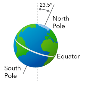
Figure-3 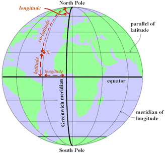
Northern and Southern Hemispheres of Earth.
The equator of earth divides the sphere of earth in two equal parts, which are known as Hemispheres. The Hemisphere towards the north is called as Northern Hemisphere and the Hemisphere towards the South is called as Southern Hemisphere. Figure-2, below shows the Northern Hemisphere and the Southern Hemisphere of the earth created by the Equator.
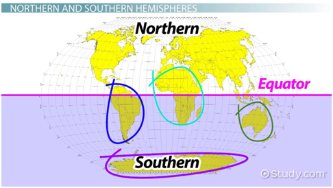
Figure-2
Geographical Longitudes and Latitudes.
Terrestrial Longitudes :- If the surface of the Earth’s is cut imaginarily by several concentric circles, passing through the north and the south poles, then each such circle will cut the Equator at a right angle. These imaginary circles are known as ‘Meridians of Longitude’. The longitude of a place is measured east or west of the Prime Meridian. The Prime Meridian on the Earth passes through the original “Royal Greenwich Observatory near London”. The meridian of longitude (circle), passing through the Greenwich is considered as the circle of zero degrees longitude. All places located east of this Prime Meridian have 0 to 180 degrees (E) east longitude. Places located west of this Prime Meridian will have 0 to 180 degrees (W) west longitude. These all are known as ‘Terrestrial Meridians’. Such longitudes from 0 to 180 degrees marked east or west, depends upon the location of a place east or west of Greenwich. 180 degree east and the 180-degree west meridians are the same meridian circles lying opposite to 0-degree meridian and it is called as the ‘International Date Line’. Ancient Vedic astrologers considered terrestrial meridians passing through Ujjain as the zero degrees longitude. The meridian passing through Greenwich was accepted as the Prime Meridian of the world at the Washington Conference of 1884. At present, the meridian passing through the Greenwich in England is considered as of zero degrees longitude. Longitude of a place is the angular distance of that place’s meridian east or west of the Prime Meridian passing through Greenwich.
Terrestrial Latitudes:- Drawing imaginary circles parallel to the Earth’s Equator, the centre’s of which falls at the axis of Earth, these imaginary circles are called as ‘Parallels of Latitude’. All places being located at the Equator have zero degree latitudes. Places located north of the Equator will have 0 to 90 degree (N) north latitudes, depending upon the location of such a place. Places located south of the Equator will have 0 to 90 degrees (S) south latitude, depending upon the location of such a place. The point of intersection of the zero degrees longitude and the Earths Equator is the reference point for locating any place on the Earth. The latitude and the longitude of pace are the coordinates, which help in locating the place accurately on the surface of Earth.
Figure-3, above shows the position of the terrestrial longitudes and latitudes.
As explained in the paras above, it shows how to locate or find a place on the surface of Earth. Thus extending these principles of locating a place on the surface of Earth, a heavenly body viz, various planets placed in the space also can be located or defined similarly. In this regard, it has been imagined that the entire space around our planet Earth, is a huge sphere with infinite diameters. So while living on this planet the Earth, the other planets in the space would appear to us to be situated on the imaginary surface of this imaginary sphere.
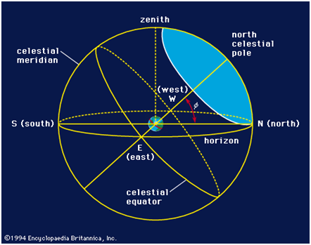
Celestial Sphere:-
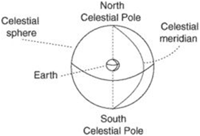
An imaginary projection of the earth in all directions up to infinity is considered as Celestial sphere. It is a cosmic sphere or what is known as ‘Brahmanda’. The celestial sphere is an imaginary sphere centered on the Earth in which all stars and other celestial bodies can be projected. A great circle joining the celestial North Pole and the celestial South poles is called as ‘Meridian. Figures-4, explain such situations.
Figure-4
Celestial Equator:-
Extending the plane of the terrestrial equator into space is called as Celestial equator. It can be said that by extending the earth’s equator indefinitely, an imaginary great circle will get created which will cut the celestial sphere into two halves. This is known as the celestial equator. It divides the celestial sphere in to northern celestial hemisphere and the southern hemisphere. Celestial sphere along with its planetary bodies that is planets appear to rise in the east and get set in the west. This has reference to the Earth’s rotation on its axis from west to east. Figures 5 & 6 define such situations. (Celestial Equator is the great circle on the celestial sphere, when every point of which is exactly 90 degrees from the celestial poles).
Figure-5
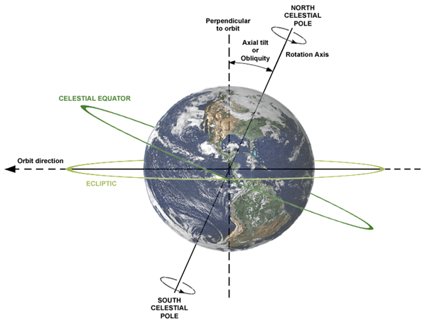
Figure-6
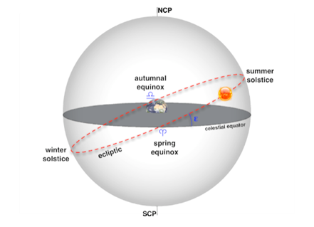
Ecliptic:- As mentioned above that in Indian astronomy, Geocentric centric observations with the Earth are followed, with the Earth at the centre of Universe and all other heavenly bodies moving around it. Sun thus also appears to revolve around the earth, rising in the east and setting in the west. This apparent path of Sun in the space along which it appears to move around the Earth is known as Ecliptic. It is actually the path of Earth in rotation around Sun. The ecliptic is the plane of Earth’s orbit around the Sun. It is also known as ‘Ravi Marg’. From the perspective of an observer on Earth, the Sun’s movement around the celestial sphere over the course of a year traces out a path along the ecliptic against the background of stars. The ecliptic is an important reference plane and is the basis of the ecliptic coordinate system. The Ecliptic is inclined approximately, at an angle of 23 degrees and 26 minutes to the plane of the celestial equator, due to the obliquity of the Earth’s axis. This angle between the Ecliptic and the equator is called as the obliquity of Ecliptic. The figure-7, below explains this situation.
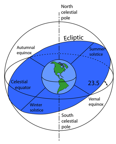
Figure-7
Zodiac:- Zodiac is a broad area of about 18 degrees extending approximately 9 degrees on either side of the Ecliptic, in which all the planets are situated, which pertain to the Vedic astrology. It can be said that the zodiac is an area of the sky that extends approximately 9° north or south as measured in celestial latitude of the ecliptic, which is the the apparent path of the Sun across the celestial sphere over the course of the year. It is to be noted here that the planets never proceed more than 9 degrees either north or south side of the ecliptic. For astrological purposes, this broad band of 18 degrees is referred to rather than referring to the entire sky. Figure-8, below explains such a situation.
Figure-8
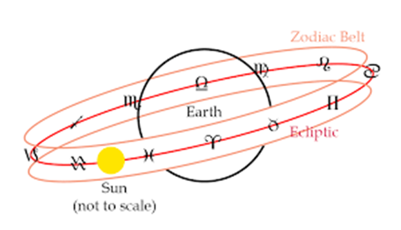
The Zodiac circular band of 360 degrees and of 18 degrees width in the heaven is further divided in to 12 imaginary equal parts of 30 degrees each. These constitute the various signs of Zodiac, which are 12 in number, starting from Aries to Pisces. Each sign is named after a particular constellation placed in it. There are 27 constellations (Nakshatras), of 13 degrees and 20 minutes each located in the zodiac evenly. As such, each two and a quarter Nakshatras are located in each sign. As Zodiac contains 12 equal parts, and each such part is of 30 degrees of the arc. Such an equal part is known as a ‘Rashi’ or a Sign. As mentioned above each Rashi or Sign contains two and a quarter “Nakhshtras”. A planet located anywhere in the Zodiac, will be considered as located in a particular sign, depending upon which 12th sign of the zodiac it is in. With the planets such a placement, it will get placed in a particular ‘Nakhsahtra’, thus identifying its location in the Zodiac in one of the Rashis of the total 12 rashis of the zodiac along with in a particular ‘Nakhshtra’, out of the 27 ‘Nakhstras (constellations) occupying the Zodiac. The ecliptic passes through the centre of the Zodiac.
The nomenclatures of various signs ( Rashis) and ‘Nakhshtras are given in detail in tables 3 and 4 of chapter – 3 of this book. . Nakshtras while being fixed , the planets called, as ‘Grehas’ are the moving heavenly bodies. These planets move from west to east along the Zodiac. In Vedic astrology nine ‘Grehas’ are taken into account. These are Sun, Moon, Mars, Mercury, Jupiter, Venus, Saturn, Rahu and Ketu. Of these, Sun is a star and Moon is a satellite of the earth. Rahu and Ketu are just mere mathematical points on the Zodiac. These shall be referred to as planets for the sake of description here after. These planets while appearing to revolve around the Earth, they maintain their presence in the Zodiac belt itself.
First Point of Aries or the Vernal Equinox:-
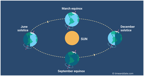
When Sun crosses from the southern celestial hemisphere to the northern hemisphere and touches the point of intersection of the celestial equator and the ecliptic, that point is known as the first point of Aries in “Sayana” system of astrology. It is also called as Vernal or the Spring Equinox. It takes place around the 21st of March every year.
First Point of Libra or the Autumnal Equinox:-
When the Sun crosses from the northern celestial hemisphere to the southern hemisphere and touches the intersection point of the celestial equator and the ecliptic, it is known as the first point of Libra in “Sayana” of astrology. It is also called as Autumnal Equinox. It takes place around 23rd September every year. Figure-10, below explains such a situation. The duration of day and night are equal when Sun crosses the Equator, that is on these two occasions of Vernal Equinox and Autumnal Equinox.
Figure-9
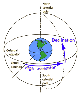
Right Ascension:-
The angular distance measured from the first point of Aries (Vernal Equinox), in sayana system, to the planet measured eastwards on the celestial equator, is called the Right Ascension. The intersection point of the celestial equator and the ecliptic is of zero Right Ascension point. As the
celestial sphere is of full 360 degrees in 24 hours, the 15 degrees of Right Ascension is equal to one hour of time. These meridian circles at intervals of 15 degrees are called as hour circles. (Right ascension is the angular distance measured eastward around the sky from the vernal equinox). There is a family of great circles that run from one celestial pole to the other and cross the celestial equator at a right angle. These are called hour circles of right ascension and they are analogous to meridians of longitude on the Earth.
Declination:-
The declination of a planet is the angular distance north or south of the celestial Equator, depending upon the planets location and is measured along the meridian through the planet. Declination is the angular distance measured north or south from the celestial equator. (Declination is an angle measured north or south from the celestial equator. This angle can be imagined as an arc drawn on a globe starting at the celestial equator and extending along an hour circle to the parallel of declination passing through the object we are trying to locate).
All objects located on the same parallel of declination have the same declination but different right ascensions. Similarly, all objects located on the same hour circle have the same right ascension but different declinations. Figure-11, below explains the situation.
Figure-10
Celestial Longitude:-
This is the distance from the first point of Aries in sayana system, to the arc crossing the ecliptic at a right angle. It can be explained as the arc of the ecliptic intercepted between the first point of Aries and a perpendicular arc to the ecliptic drawn from the location of the planet from the poles of the ecliptic.
Celestial Latitude:-
It is the angular distance across the celestial sphere measured north or south from the ecliptic along the great circle passing through the poles of the ecliptic and the planet. To put it clearer it is the perpendicular falling on the ecliptic from the planet from the north or the south of the ecliptic depending upon the location of the planet. Figure-12, below explains the situation.
The celestial longitudes and latitudes which refer to astrology are measured along and on the ecliptic.
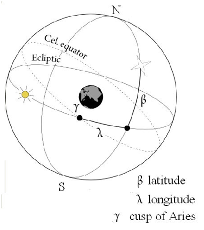
Figure-11
Summer Solstice: –
After the Vernal equinox, the Sun symmetrically attains north declination until it reaches a maximum of 23 degrees and 28 minutes. This happens around 21st of June and is known as Summer Solstice. The northern hemisphere experiences the longest day and the shortest night on this occasion. The southern hemisphere experiences the shortest day and the longest night on this occasion. Sun is said to be vertically above the “Tropic of Cancer” on this occasion. The line joining all the points at this latitude is called as the ‘Tropic of Cancer’. Ujjain an important city of M.P. which was known as “ Avantika” in earlier times, lies near the Tropic of Cancer, when Ujjain was an important centre for astronomical observations and researche.
Winter Solstice:
After the Autumnal equinox, the Sun progresses southwards. It attains a maximum south declination of 23 degrees and 28 minutes. This situation occurs around 22nd of December. The northern hemisphere experiences the shortest day and longest night. The southern hemisphere experiences the longest day and the shortest night. Sun is said to be vertically above the “Tropic of Capricorn” on this event. The line joining all the points at this latitude is called as the ‘Tropic of Capricorn’.
Formation of Seasons:-
The Ecliptic is inclined approximately, at an angle of 23 degrees, 26 minutes and 25.2 seconds to the plane of the celestial equator, due to the obliquity of the Earth’s axis. This angle between the Ecliptic and the equator is called as the obliquity of Ecliptic. During the Earth’s rotation on its orbit and its rotational axis being tilted at 23 degrees, 26 minutes and 25.2 seconds to the vertical of ecliptic, Sun appears to move northwards or southwards in relation to the Earth’s position, giving rise to the formation of seasons. When it is summer in the northern hemisphere, it is winter in the southern hemisphere and vice-versa
Precession of Equinoxes
Vernal Equinox and the Autumnal Equinox have been described above in detail. It has been observed that the Vernal equinox or the First Point of Aries, from where the longitudes (Sayana) of all the planets are measured along the Ecliptic is not a fixed point. Every year as soon as the Sun reaches the Vernal Equinox, the position of Earth, with respect to some fixed star, shifts by 50.29 seconds of the arc westwards, compared to its position at equinoctial position of the previous year. Thus, the Vernal Equinox point recedes back along the ecliptic at the rate of 50.29 seconds every year. This retrograde motion of the equinoxes is known as ‘the ‘Precession of Equinoxes”. This is the position in the ‘Sayana’ system. In the ‘Niryana’ system the ‘First Point of Aries’ is fixed, with respect to a particular star. This ‘Precession of Equinoxes’, gives rise to the ‘Sayana’ and the ‘Niryana’ systems along with the concept of ‘Ayanamsha’. In this regard, the concept of ‘Movable’ and the ‘Fixed’ Zodiacs needs to be understood first.
Fixed and the Movable Zodiacs.
Due to the precession of equinoxes, the Vernal Equinox, slips backwards from its original position. The Zodiac, which reckons the first point of Aries from the Vernal Equinox, is known as the Movable Zodiac or the Tropical Zodiac. In the case of Fixed Zodiac, which is also called as ‘Sidereal Zodiac, the first degree begins from the first point of Aries (Mesha), reckoned from a particular star in the Revati group of stars.
Ayanamsha, Sayana, and the Niryana Systems :-
Procession of the equinox as mentioned above takes place because of wobbly motion of earth as it is bulging at the equator. The Moon and the Sun exert gravitational pressures, which leads to slight change in rotation of earth on its axis. This procession of the equinox creates Sayana and Nirayana system.
As already mentioned, due to the precession of equinoxes at a rate of 50. 29 seconds per year, the distance between the Vernal equinox (the first point of movable Zodiac) and the first point of Aries (Mesha), on the fixed Zodiac, has progressively been increasing. This difference between this fixed initial point and the Vernal equinox is known as Ayanamsha. It can be said that the angular distance measured along the Ecliptic, between the first point from where the fixed Zodiac commences and the Vernal Equinox point at an epoch is known as Ayanamsha. It is the Ayanamsha, which differentiates between the Fixed Zodiac and the Movable Zodaic. The system which considers the fixed Zodiac is called as the Niryana (without ayana) system. The one which considers the movable Zodiac, is called as Sayana (with ayana) system. After applying the Ayanamsha correction to this, the Niryana longitudes are found.
These two equinoxes would have coincided with each other at some point of time in the past. But it is not exactly known as to when these two equinoxes have met in the past. Various astrologers about it have given different views, when Lahiri considers the starting year of Ayanamsa as 285 AD, Dr.B. V. Raman as 397 AD, Krishnamurthi as 291 AD, and Yukteshwar as 499 AD. In view of the above controversial viewpoints, the present Ayanamsha varies from 19 degrees to 24 degrees approximately. However, the Ayanamsha reckoned on the basis of considering the year 285 A.D, as the year, when the Sayana and the Niryana Zodiac coincided, which is called the ‘Chitrapakhsha Ayanamsha is the one which is followed as per N.C.Lahiri in his Ephemeris. As per the “Chitrapaksha Ayanamsha”, it is said that these two zodiacs have coincided in 285 A.D, when the Ayanamsha was zero. This is taken as an authentic “Ayanamsha” for astrological purposes as per a reliable and a sound research, conducted on this subject. Its application gives accurate astrological predictions.
The importance of the Ayanamsha bears credence to the fact that the fixed Zodiac (Niryana System), has a permanent relationship with the star constellations or ‘Nakhshatras’, where as the movable Zodiac ( Sayana System ), does not give a definite position for predicting accurately. The Vedic astrologers use the Niryana system, while as the western astrologers use the Sayana system. The planetary longitudes are measured from the Vernal equinox that gives the Sayana position of the longitudes. After applying the Ayanamsha correction to this, the Niryana longitudes are found. The standard tabular details about the Ayanamsha corrections are mentioned in the Lahiri’s Indian Ephemeris.
How to calculate Approximate Ayanamsha:-
Step -1>> Subtract 285 from the year of birth.
Step -2>> Multiply the remainder by 50.29 seconds. It will give results in seconds.
Step -3, Convert the product in degrees, minutes and seconds. That will be the approximate Ayanamsha.